|
Examples
For
inspiration and fun
Below
in random sequence some examples. Scroll along light rail in Nottingham
(UK), Valencia (ES), Rome (IT), Saarbrücken (DE), Tokyo (JP), Zwickau
(DE), Salt Lake City (UT, US) and Kiev (RU).
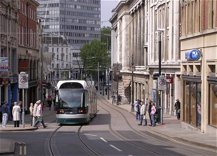
Photo: (C) Light Rail Atlas/Rob van der
Bijl
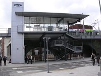
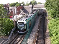
Nottingham, centre, May 27, 2004
 NET - Nottingham Express Transit
The
new tramway of Nottingham (UK) - Nottingham Express Transit line 1 -
has been launched March 8th (2004) by Alistair Darling, the Secretary
of State for Transport. It took sixteen years of planning and more than
three years of construction to make this Grenoble inspired tramway a
reality. NET is a state-of-the-art tram system, which is successful
already. It runs from Hucknall, through Bulwell and Hyson Green and
into the city centre, terminating at Nottingham railway station. There
is also a spur line to Phoenix Park (just off the M1 at junction 26).
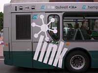
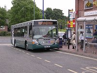
NET is integrated system.
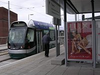
16
scenes
NET represent all features of light rail. These 16 scenes prove
that Light Rail is a high quality and a flexible technology. The pictures
show light rail as elevated railway, as a classic street tramway, as
single track railway, connecting city and region. The stops are busy,
the buses are linking. Along the tram route, there are 23 stops with
five Park and Ride sites (Hucknall, Moor Bridge, Phoenix Park, Wilkinson
Street and The Forest). In the city centre, there are stops at Royal
Centre (for the Theatre Royal, Royal Concert Hall and The Cornerhouse),
Old Market Square, in the heart of Nottingham and Lace Market, for the
National Ice Centre and Hockley.
  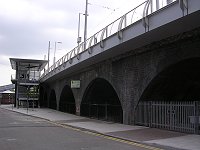 
 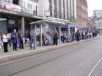 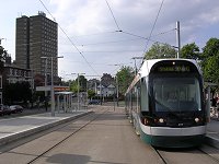 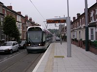
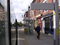   
 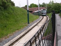  
All pictures: (C) Light Rail Atlas/Rob van der Bijl
Nottingham, May 27-28, 2004
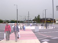
Valencia City and region along the eastcoast
of Spain entail an efficient and contemporary light rail network. Some
old regional tramways and railways have been converted and integrated
in todays network.
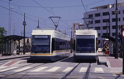
Photo: (C) Carlos Pérez Arnau (carlos@studio3.es)
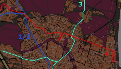
Map: Valencia (C) Light Rail Atlas, 2000
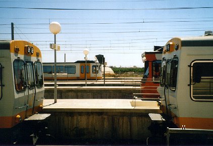
Photo: (C) j.jimenez@vitalicio.es
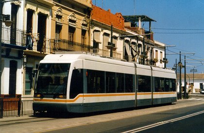
Photo: (C) Carlos Pérez Arnau (carlos@studio3.es)
Rome Since March 1998 trams of ATAC (Azienda
Trasporti di Rome) are riding again in the streets of the historic centre
of Rome. A new route 8 connects the southwestern part of the city to
Largo di Torre, partly via the new Trasteverre alignment. An extension
to Roma Termini is planned in 2001.
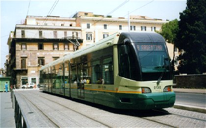
Photo (C) Light Rail Atlas, Rome, August 10, 1999
Green
low floor tram in historic centre
Route
8 represents the first Light Rail-project, which is financed in confirmity
with "law 211".
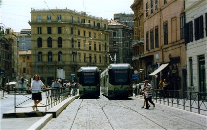
Photo (C) Light Rail Atlas, terminus Largo
di Torre, August 10, 1999
100% low floor vehicles are in service during the beginning of 1999.
Surpisingly the new trams use the old green livery. They are built by
Fiat Ferroviaria; their nickname is 'jumbotrams'. Fiat Ferroviaria will
also produce a second, completely different batch of low floor cars.
Saarbrücken 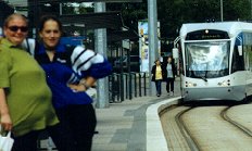
All pictures Saarbrücken: (C) Light Rail Atlas / Rob van der Bijl,
August-December 1999
In
October 1997 trams returned to the streets of Saarbrücken in Germany
(the old ones left in 1967). This new Light Rail system uses a new track
in the innercity, from Cottbuserplatz to Brebach. The line continues
from here to the French bordertown Sarreguemines (Saargemund) via heavy
railtracks of the Deutsche Bahn (DB), along the valley of the river
Saar.
The Light Rail Vehicles (built by Bombardier) are suitable for operation
in streets and on heavy railways. So, it is possible to build relatively
fast and cheap the first line of a future regional network.
View from the temporal office of Light
Rail Atlas in Saarbrücken, Augustus 20, 1999
The
new system is doing well. There is a substantial growth of (new) passengers.
The centre-part of the line is extremely succesfull. This part is also
the backbone of the reorganized (feeder-)bussystem. At the moment an
extension of the line to Brebach is under construction. The first part
of this new branche (to southern Riegelsberg) will use new streettracks.
The second part will be built on an old heavy railline, bought for 1
mark (1/2 dollar) from the national railway company (DB).
In the summer of 1999 a temporal line 2 was in operation from Saarbrücken
centre - via the new DB-connection - on tracks of the DB to the Messe
(Expo). This temporal line illustrates the rather easy way of extending
the system into the region. Like Karlsruhe (also in Germany) Saarbrücken
already represents a new succesfull duo-system.
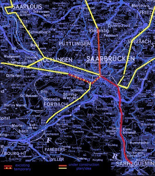
Map: (C) Light Rail Atlas, November 1999
The
new system of Saarbrücken is a very constructive example for comparable
situations in Europe, America and other parts of the world. Cities like
Luxembourg (L), Mulhouse (F), Leiden (NL), Groningen (NL), Kiel (D),
Wiesbaden (D), Oporto (P), San Diego (USA), Los Angeles (USA), Melbourne
(AUS), and many others can learn a lot of this recent German precedent.
The importance of the Saarbrücken experience justifies a large
quote from our German source. This quote is taken from Martin Karr's
'Mehrsystemkonzepte der Schienenbahnen in Europa' (Technical University
of Karlsruhe (TH), 1998). Note: 'EBO' is the German standard for heavy
railway, 'BoStrab' for tramway.
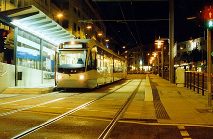
Photo (C) Light Rail Atlas, Saarbrücken, August
20, 1999
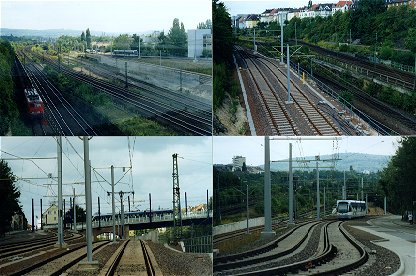
Photo (C) Light Rail Atlas, Saarbrücken,
August 21, 1999
Connection to heavy railtracks near Cottbuserplatz
Photo (C) Light Rail Atlas, Saarbahn in centre, August
21, 1999
Photo (C) Light Rail Atlas, Saarbahn in Brebach , August
21, 1999
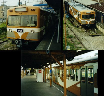
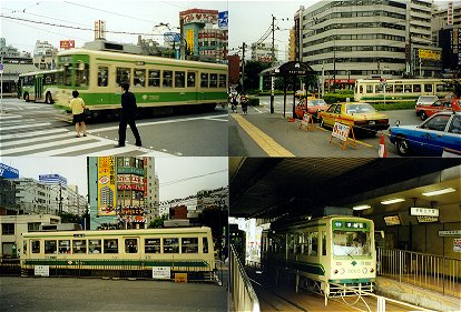
Tokyo 
Kyuko
Dentetsu In Japan Light Rail as traditional tram has
a limited meaning. Just the city of Hiroshima owns a larger classical
tramway. However Light Rail in the form of wellknown 'interurbans' is
still very important in Japan. Many of these systems have developed
into urban-regional railways.
An
example of such an urban railway is the 'Tokyo Kyuko Dentetsu', which
means the 'Tokyo Electric Express Railway'. Kyuko Dentetsu is one of
the biggest private urban railway companies in Japan. The network of
Tokyo contains seven train lines and one tram line (Setagaya-sen). Total
lenght: over 100 kilometer. Daily amount of passengers: 2.6 million.
The region of Tokyo has been urbanized heavily. The railway lines of
Kyuko Dentetsu have helped to structure urban growth.
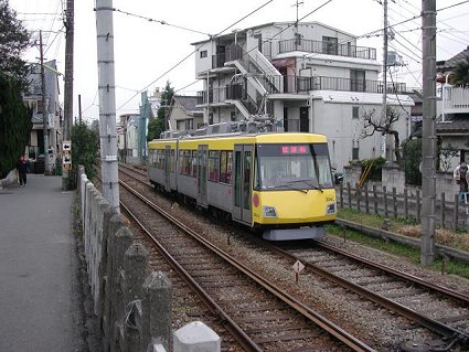
Photo: (C) Light Rail Atlas/AUTUMN, October
2002
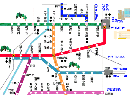
Map: (C) Light Rail Atlas/Kyuko
Dentetsu, June 2003
The Setagaya-line is in blue. The map represents a part of the Tokyu
network between Tokyo and Yokohama
Setagaya-sen
This one line Light Rail system is located at the western side of
the Tokyo conurbation. The line from Sangenjaya (at the Shin-Tamagawa-sen)
to Shimotakaido (connection to the Keio-sen) is 5.1 km long and has
10 stations, all new, high platforms. It is the last survivor of the
Tokyu tramway network. The cars still use 600 V and their gauge is 1372
mm, as on all trams in Tokyo. 53.000 passengers use the line every day
(2000).
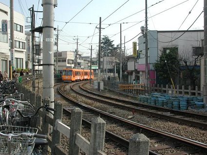
Photo: (C) Light Rail Atlas/AUTUMN, October 2002
The new cars have a different livery each.
The
Tokyo Kyuko Dentetsu is a private company. Like many of these companies
in Japen it is not subsidized. Therefore this kind of railway companies
are developing retail and real estate around their station areas. This
works out te be a fine solution. The commercial activities generates
both money and passengers!
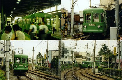
Photo's: (C) Light
Rail Atlas/Manuel López, September 1998
"Hurry
up!", shouts the girl, but the white-gloved driver of car 75 is
still busy. Light Rail Atlas likes these typical Japanese LRV's!. However,
the old green ones have been replaced by new rolling stock, which has
been put in service during 2000-2001.
Sobu-Nagareyama
Dentetsu K.K. Many former tramways were transformed into urban railways.
This is an example at the eastern edge of the Tokyo metropolitan area.
Long ago it was a narrow gauge steam railway which was eventually transformed
into a rural tramway. Now the line (12.8 km) is an integral part of
Tokyo's electric commuter railway network.
Photos: (C) Light Rail Atlas/Manuel López,
September 1998
The
photos show secondhand trains from the Seibu interurban system. Manuel
López of Light Rail Atlas is asking himself if there is anybody
who wants to use this quiet Light Rail-system.
Arakawa (Tokyo)
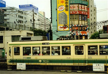
Photo: (C) Light Rail Atlas/Manuel López, September
1998
The
city of Tokyo owns a single tramway line (12.2 km.), which used to be
part of the former large tramway network. But in 1967 Tokyo decided
to enlarge the metro system and to transform or close nearly all tramways.
During the eighties of the last century new trams of the Japanese firm
Alna Koki have been put into service.
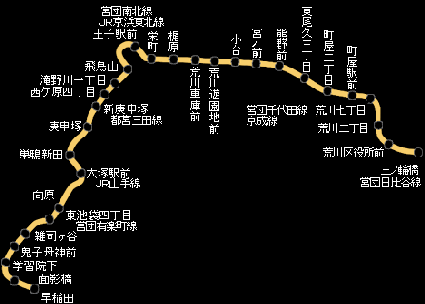
The Arakawa-line represented on scale (above)
Maps/photo: Light Rail Atlas/Kuri/TRTA
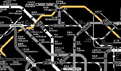
The
schematic map shows the Arakawa line (orange) in context of the northern
part of the railway and metro system (in grey and white). The municipal
line is upgrated to light rail standards. This means the tramway is
located predominantly right of-way and uses high platforms. However,
much street operation still excists.
Photos: (C) Light Rail Atlas/Manuel López,
September 1998
The
pictures show impressions of the eastern terminus situation of the Arakawa
tramway. Car 7505 is speeding up, while 7005 is at the terminus building.
The other two photos show car 7031 on duty.
Tokyo Metro
Tokyo is a huge and complicated metropolis. The metro system is operated
by two companies. The first and oldest one (1927) is the privately owned
'Eidan Underground', shortly 'Eidan', or 'Teito', in English abbreviated
as TRTA, Teito Rapid Transit Authority. Since April 2004 the Eidan-metro
is called 'Tokyo Metro'. The second operator is the municipal transport
company of Tokio, Tokyo-to Kotsu-kyoku, shortly 'Toei'.
The development of the metro system resambles the complex growth of
Tokyo. The system is unique. There is through running of regional railways
on the metro network, and vice versa. The operational and technical
characteristics vary enormously. Type of vehicle and service, gauge
width, power supply, signalling, and train control depend on the specific
line or group of lines.
Tokyo's metro stations get beautiful names, like Asakusa, at the oldest
line of the system, which is called Asakusa as well: 'the low gras'.
Or at the Nanboku-line station Sendagi: 'the tree with thousands burdens'.
At the southwest branche of the Marunouchi-line to Hònanchó
one station before the terminus wins the prize of Light Rail Atlas for
the most beautiful name. The station is called 'Nakanofujimicó',
which means 'the district in the fields from which one sees the mount
Fuji'.
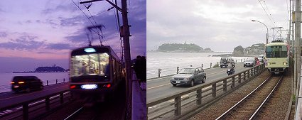
Enoden
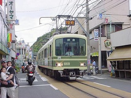
Photo: (C) Light Rail Atlas/TERRA, Enoshima,
May 4, 2002
At
the south side of the Tokyo-Yokohama urban region, a ten kilometer 'interurban'
style tramway connects Enoshima with Fujisawa and Kamakura. This light
rail system is called Enoden. The cars come in a variety of styles (1927-1997).
The Enoden Light Rail advertises itself as a retro-railway. Built in
the early 1900s as a tourist line, it now also serves commuters and
shoppers.
The Enoden is located predominantly right of-way and uses high platforms.
In the city of Enoshima the cars run through the main street.
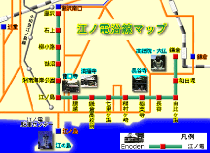
The
fifth station from Kamakura brings one to Hase, home of the Great Buddha
(see map). This beautiful light rail starts in Fujisawa on the roof
of the Enoden-mall. Fujisawa is connected via Yokohama to the regional
train system of Tokyo. In Enoshima a monorail runs to the station of
Ofuna.
Photo's: (C) Light Rail Atlas/TERRA, January
11, 2003 & May 4, 2002
The
Enoden Railway winds through back streets of Kamakura, cruises along
the ocean with superb views of Enoshima, up the main street of Koshigoe,
through the posh neighborhood of Kugenuma. The Miura peninsula fits
in this light rail landscape.
Zwickau
At the end of 1999 tram/trolley (GT6M, AEG; KT4D, CKD TRAKCE) and train
(RegioSprinter, DUEWAG) of the former East-German city Zwickau will
use a common track between the centre and the south. Two worlds will
be merched: tram-based light rail and light railways.
The RegioSprinters of the Vogtlandbaan (regional network on tracks of
Deutche Bahn) are guests on the tramway network. Therefore the RegioSprinters
are adapted to the German tramway standards, namely the so-called 'BOStrab-Einrichtungen'.
The RegioSprinter is a real Light Rail Vehicle; this LRV posseses much
properties of a modern low-floor tram. Entering is comfortable and the
interior is spacious. It is even possible to store bikes and there is
a restroom.
Zwickau
Map - in green the route of the RegioSprinter.
Urban tramways in red.
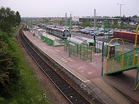
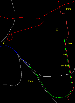
Salt Lake City 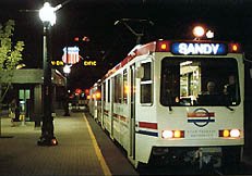
The
Salt Lake City system has been enlarged soon after its start. A branch
of the main line - from Union Pacific to the university - opened December
2001.
The university line provides a direct link between the campus and downtown,
giving students a way to get to class without having to take up parking
spots. But before any of those get underway, the U has one more line
it wants built. Construction crews will extend the university line from
the stadium to University Hospital, connecting lower campus to upper
campus. (Daily Utah Chronicle)
The University Light Rail is being used to significantly improve access
to jobs, educational opportunities, health care, and housing throughout
the 400 South corridor. The capital cost of the 2.5-mile University
line totals $105.8 million.
The
University Line provided transportation during the Olympic Games, as
well as transportation near the Olympic Village located on the University
of Utah campus.
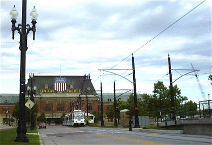
Photo: courtesy John Williamson, July 2000
De
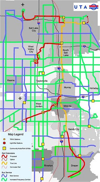
The Utah Transit Authority (UTA) has implemented a 15-mile light rail
transit (LRT) line from downtown Salt Lake City along State Street then
paralleling I-15 to suburban areas to the south. The line opened for
regular weekday service on December 6, 1999. The South LRT line operates
at-grade on city streets in downtown Salt Lake City (two miles) and
on a railroad right-of-way (13 miles) owned by UTA to the suburban community
of Sandy. The total cost of this project is estimated at $312.49 million
(escalated dollars). Although the South LRT was estimated to carry 14,000
passengers per day in 2000 and 23,000 passengers per day in 2010, current
ridership has already exceeded 26,000 weekday riders. A total of 21
light rail vehicles have been ordered and delivered for the project.
The
South LRT project is one component of the Interstate 15 corridor improvement
initiative, which includes reconstruction of a parallel segment of I-15.
(Federal Transit Administration, November 2001)
Map:
UTA
Recall
of construction...
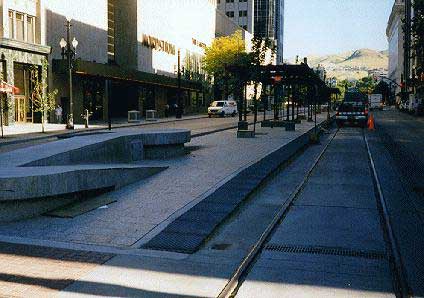
Photo: (C)
Light Rail Atlas/Rob van der Bijl
Salt Lake City, summer 1998
Light
Rail Atlas viewed work in progress during the summer of 1998. For example
the Mainstreet section under construction, including centre platform
halts with high blocks for wheelchairs, and...
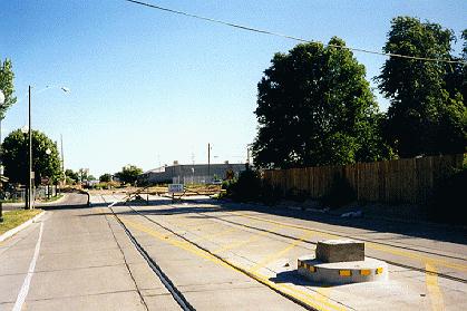
Photo: (C)
Light Rail Atlas/Rob van der Bijl
Salt Lake City, summer 1998
...encountered
the end of the street section, just before entering the former Union
Pacific railroad branch.
Kiev
Bad
news from Kiev - According to our LRTA-source, on the 9 of June, a large
section of the Kiev tram lines (from Square of the Great Patriotic War
to the Leningradska sq., route # 21, 27, 31) were suddenly abandoned.
The decision to abandon the tram lines was taken by the city mayor without
notification to passengers. The last tram with passengers passed the
Paton bridge at 20:00. Immediately after that workers began to remove
rail tracks from the bridge.
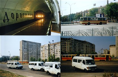
New
metro, old trolleybus and new bus-taxis
Photo: (C) Light Rail Atlas/Rob van der Bijl; Kiev, August 12, 2001
The
performence of many of the tramways in the former Sovjet Union is not
very well. There is a lack of money; insufficient maintainance and new
investments. In many cities private bus-taxis compete with the trams,
for instance in Kiev. The director of the tramway in Vladivostok has
been murdered in the summer of 2001 by the mafia bustaxi-operator after
she had planned to reorganize the bustaxi in her city in order to end
the rivalry.
Kiev has planned a new light rail line from Vatutinsky in the northeast
to the centre. However, the construction has been postponed for at least
two years due to money spending for a new national monument in de centre
of Kiev. Recently a plan is revealed to close a large part of the tramway
system.
After years of delay a new Kiev-metro extensition is opened in 2001.
A year later such extensions came into operation in Novosibirsk (Russia)
and Tashkent (Uzbekistan).
Some tramway routes has been abondened in the inner city of St.Petersburg.
Some routes in other cities are also closed.
Nevertheless there is some good news as well. Moscow renews the tramway
and introduces new trams (KTM19). In some other cities new Tatra-trams
has been introduced as well, for example in Dnepropetrovsk (Ukraine)
and Tashkent (later this year).
The Moscow-metro is extended substantially. New designed light rail
lines in the periphery of the city will be used as feeders to the metro.
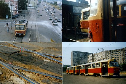
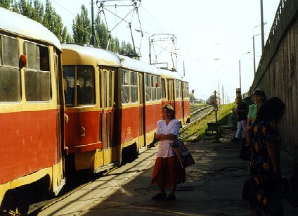 Photo: (C) Light Rail Atlas/Johan Meijer; Kiev, July
2000
Photo: (C) Light Rail Atlas/Johan Meijer; Kiev, July
2000
The trams of type T3, built in Prague, run on the city network, as well
as on the express tramways of the light rail system. It is no big deal
for the ordinary public. They just wait for the (next) tram.
The
city of Kiev in the Ukraine owns a large tramway network (1892). Since
1979 Kiev built a small network of 'express tramways', which earns -
despite its simple form - the predicate light rail.
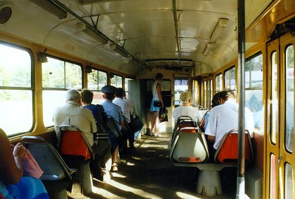
Photo: (C) Light Rail Atlas/Johan Meijer;
Kiev, July2000
This
is what the municipal administration says:
There
is a complicated system of city transportation functioning in Kyiv [Kiev,
volgens de officiële spelling; LRA]. The transportation of passengers
in the city is done by subway, tramways, trolley-buses and buses as
well as by automobiles. In 1991-1996 special attention was paid to the
development of such kinds of transport as subway and high-speed tramway
[light rail; LRA].
The most important part of the transportation network of Kyiv of
those built recently is Siretsko-Pecherska subway branch along with
the Pivdenniy bridge across the Dnipro river built for both subway and
automobiles.
In the southern part of the left bank, in Troyeshchina, there is the
construction of the first high-speed tramway complex going on, and the
branch of this tramway is connecting the largest district of the city
with the subway branches and the central regions of the left bank.
[though progress is unclear; LRA]
During the last five years, despite the lack of funds, the pace of
the construction of the subway in Kyiv tripled from 1 km to 3 km per
year.
The big problem for the city is the rapid growth of the number of cars.
At the beginning of the year 1997 (according to the Kyiv Municipal Statistics
Department) the number of cars compared to the beginning of 1991 increased
more than 1.5 times and made 333.5 thousand of cars or approximately
127 cars per 1000 people. There is an expanded electric transportation
network (26 tramway and 34 trolley-bus lines) that has a lot of problems
as well.
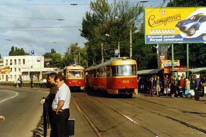
photo: (C) Light Rail Atlas/Johan Meijer;
Kiev, July 2000
The system is built between 1967 and 1978. It is an enlargement of the
city network at the west and southwest side of the urban area, connecting
a huge new housing site with the centre of the city. It is operated
by three lines. Line 1 (opened in 1980) starts in the centre (Palats
Sportu) and shares the first few kilometers with some conventional tramways.
At the edge of the centre (Pl. Peremogy) the actual light rail alignment
commences. At that location the terminus of 1K and 3 (opened in 1979)
is situated.
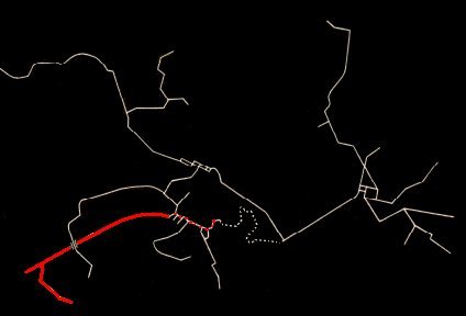
Partly
closed city network (grey) and still existing express network (red)
Kiev
Map: (C) Light Rail Atlas, December 2000 - January 2012
The
light rail system contains about 14 kilometer segregated double track;
the complete network (1994) contains about 120 kilometer of double track.
At the edge of the urban era the express tramway splits into two branches;
line 3 runs straight on for 1 kilometer, while line 1 keeps a southern
direction for some kilometers. A depot is connected to this later branche.
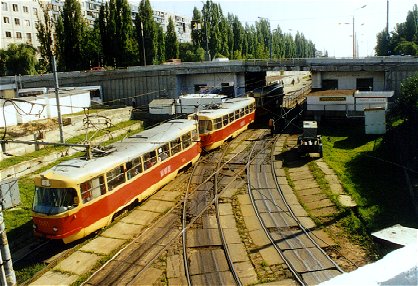
Photo: (C) Light Rail Atlas/Johan Meijer; Kiev, July
2000
A
TramTrain containing 3 Tatra T3's of line 3 on its way to Kil'tseva
Doroga is just passing the division of the two branches.
The system is elaborated soberly. Stops and viaducts are materialized
in rough concrete. The shape of the system looks reasonable, that is,
compared to the general state of infrastructure and public transport
in the Ukraine. Tracks, vehicles and amenities are well kept.
Officially
the light rail systeem is still under construction. The current network
should be extended to Troyeshchina, a large district on the left bank,
in the southern part of the city. For long time however there isn't
any news on progress of this project.
In the meantime the metro is enlarged continually, officially about
1-3 kilometer each year.
Photos:
(C) Light Rail Atlas/Rob van der Bijl; Kiev, August, 11/12, 2001
Back
to the top
of this page.
|